MA8100A
Anritsu
MA8100A
Product specifications
| SKU | ANR-MA8100A |
|---|---|
| Manufacturer | Anritsu |
Documentation
Please use the icons below to download any files related to this item. We aim to have the datasheet and/or catalog available.
Description
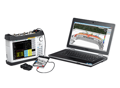
The NEON MA8100A Signal Mapper is a 3D in-building coverage mapping solution for use with Anritsu handheld instruments. Instruments supported include Field Master Pro, LMR Master, Spectrum Master, Site Master, BTS Master, Cell Master, and VNA Master.
Where GPS is unavailable, the Anritsu MA8100A Series solution delivers real-time 3D location information for indoor test and measurement applications. Available with 1, 3 and 5 year licenses, the MA8100A Series consists of a NEON Tracking Unit, NEON Signal Mapper Software for Android devices, NEON Command Software, and TRX Cloud Service.
The NEON Tracking Unit supports collection and processing of sensor data that delivers 3D location information. The NEON Signal Mapper Application provides an intuitive Android user interface enabling lightly trained users to map signal and sensor information within buildings; users can initialize their location, start/stop mapping and upload/download mapping data to/from the cloud. The NEON Command Software enables creation and visualization of 3D building maps and provides centralized access to the NEON Cloud Service to access stored maps and measurement data.
Integrating NEON’s capability to automatically collect geo-referenced test data with Anritsu handheld spectrum analyzer products saves valuable time and money by
- Eliminating the need to manually perform "check-ins" at each test point by automatically calculating indoor location
- Providing vastly more data than is possible with manual processes by recording data with every step
- Removing typical data recording errors caused by "guesstimating" locations in large buildings through automatic indoor location and path estimation
- Delivering actionable data in areas not easily analyzed such as stairways and elevators by recording and referencing measurements in 3D
- Enabling quick analysis of signal coverage and faster problem resolution by delivering the industry’s only geo-referenced 3D visualization
- Providing color-graded measurement results in 2D and 3D views. Measurement values can be seen by clicking on each point. A .csv file of all measurements is also provided

